Track information
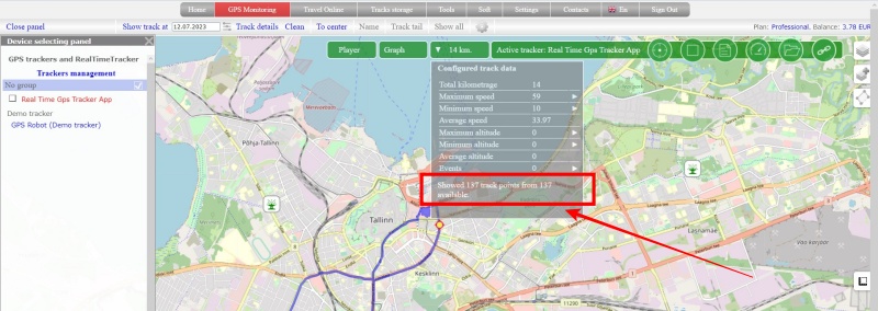
After building the track, a panel with mileage will appear. Click on it and a window with additional information on the track will open.
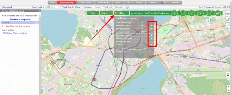
Pay attention to the arrows located on the right side of the information window next to some parameters. These are buttons that you can click on to reveal more details.
The displayed information is calculated only from the displayed data. That is, if the track was built using filtering, then all indicators will be calculated only according to the data that fell on the track visible on the screen.
Values of output parameters:
- Total kilometrage - the total length of the displayed track
- Maximum speed - the maximum speed that is present on the displayed track. When you press the “arrow” button, the track point where the given speed was recorded will be shown
- Minimum speed - the minimum speed that is present on the displayed track. When you press the “arrow” button, the track point where the given speed was recorded will be shown
- Average speed - average speed of movement
- Maximum altitude - The maximum height that is present on the displayed track. When you press the “arrow” button, the track point where the given speed was recorded will be shown
- Minimum altitude - the minimum height that is present on the displayed track. When you press the “arrow” button, the track point where the given speed was recorded will be shown
- Average altitude - average height, calculated from the data of the displayed track
- Events – if points with events are fixed on the displayed track, their number is displayed. Pressing the arrow button opens the event log
Pay attention to the indicator “Showed N points from M available.”
Depending on the tracker operation mode, the track for the selected date may consist of a large number of points. The amount of data displayed on the map can be so large that the power of your computer and the capabilities of any of the existing browsers simply may not be enough. To avoid such a situation, we make a forced filtering of the track and can display not all points on the map.
If it seems to you that the track is poorly detailed, look at how many points are displayed.
If all points are displayed, this means that your tracker did not send anything other than what was displayed on the map.
If not all track points are displayed, it means that some of them are subject to forced filtering. In this case, try to build the track taking into account the time in order to see some of its parts in more detail.